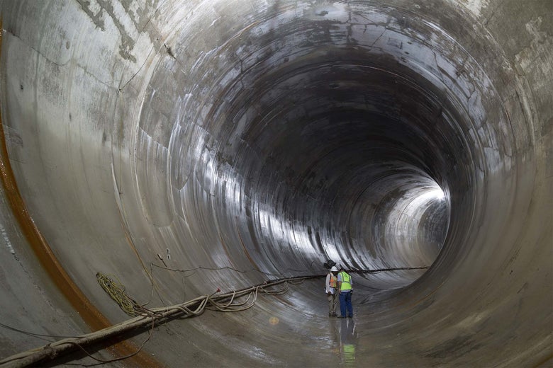
Construction workers lean in to discuss the project over the noises echoing throughout the Deep Tunnel. Photos by David Schalliol.
CHICAGO—That the Chicago River is reborn, that its tree-shaded promenades are thronged with strolling families, that new buildings turn toward the water and old buildings have opened new windows to face it, that people kayak in what was once an open cesspool in the middle of downtown—all of this is a point of pride here. People laughed when then-Mayor Richard J. Daley said in the ’70s that he’d one day like to see people grilling freshly caught fish on the river’s banks. Though it would have seemed insane in 1980 (or 1880), people do fish in the Chicago River today, and the number of species to be found here has multiplied tenfold in the past four decades.
That’s because Chicago built a second river, an infernal reflection of the first, tracing its course hundreds of feet below ground. On rainy days, this subterranean passage, a conduit that can hold more than 1 billion gallons of wastewater, welcomes a roaring torrent of shit, piss, and oily runoff from the downtown streets. This megasewer, a filthy hidden portrait to the Chicago River’s Dorian Gray, is dynamic enough to create its own wave action if not properly supervised. That’s what happened on Oct. 3, 1986, when a geyser blasted through a downtown street, lifting a 61-year-old woman’s Pontiac Bonneville into the air like a toy, nearly drowning the driver in dirty water.
Altogether, 109 miles of subway-size tunnel lie beneath Chicago and its suburbs, covering more miles than the L, culminating in three suburban reservoirs (not the kind you drink from). This is the Deep Tunnel, formally the Tunnel and Reservoir Plan, and it may be the world’s most ambitious and expensive effort to manage urban flooding and water pollution. It is a project, in the visionary tradition of Chicago engineering, to bottle rainstorms.
According to the Metropolitan Water Reclamation District of Greater Chicago, the agency that built and runs the project, the tunnels and reservoirs protect 1.5 million structures from flooding, in addition to keeping sewage out of Lake Michigan and the Chicago River. Though not quite finished (the tunnels are done, the reservoirs are not), the scheme has been and is being imitated in cities like Milwaukee, St. Louis, D.C., London, and Guangzhou, where the concept, 50 years after it was undertaken in Chicago, is seen as the state-of-the-art solution to flooding damage and water pollution.
The history of Chicago can be told as a series of escapes from wastewater, each more ingenious than the last.
Kevin Fitzpatrick has worked on the Deep Tunnel for 15 years. An engineer with the MWRD, Fitzpatrick has been in the job long enough that, on the November day when we enter the pumping station that gradually empties the tunnels into a nearby water-treatment plant, he no longer notices that the whole building smells like hydrogen sulfide. One thing he does remember very clearly is having to clean dirty water out of his basement as a teenager in the 1980s: “My dad probably told me after, ‘You know what that is? Crap.’ ”
When Fitzpatrick was growing up on the South Side, the Government Accountability Office estimated Chicago was sustaining nearly $100 million in flood damage every year—not counting the cost of pollution. The MWRD thought it was closer to $200 million. Chicago sewers were emptying into the river 100 days a year, overwhelmed by as little as a third of an inch of rain. When it rains in Chicago (or New York, or virtually any prewar metropolis with “combined sewers”), every drop that goes down a drain mixes with sewage. The sewer engineer’s riddle: What do you get when you mix a gallon of sewage and a gallon of rainwater? Two gallons of sewage.
Fitzpatrick drives me to McCook Reservoir, the mammoth holding pen, opened in late 2017, for the tunnels that run beneath the Chicago and Des Plaines rivers. We stand on the edge of a pit that can hold 3.5 billion gallons of wastewater, enough to fill the Empire State Building and then some. It doesn’t smell terrible, thanks to floating aerators and because the pool has dwindled to 30 feet deep—Friday’s leftovers from a half-inch of rain on Tuesday. At the far end we can see the circular tunnel mouth leading downtown. The city’s wastewater netherworld has its own Chicago-centric measurement system. Lake Michigan is elevation 0. The pumping-station control room, on a little hillock, is +25, or 25 feet above the lake. The roaring motors that empty McCook after the rain sit at -297, 30 stories below ground.
Behind us, the second section of McCook—which will more than double the holding capacity of the Mainstream Tunnel—is being excavated by gigantic mining trucks. Vulcan Materials, the country’s largest vendor of crushed rock, is digging millions of cubic yards of limestone out of the ground. That aggregate winds up in the concrete that abets Chicago’s downtown building boom. When those new residents take a shower or flush the toilet during a rainstorm, the water winds up here.
This whole endeavor, Fitzpatrick says, has been an unreserved success. “To have today’s types of storms without this capacity, I don’t think we could function as a modern city. A modern city shouldn’t have people’s homes flooded with sewage. It shouldn’t have a dead river without fish in it.” But, he adds, it’s now clear that this 50-year, multibillion-dollar project will not be sufficient to stop flooding in Chicago. In fact, far from building a catchall for Chicago wastewater until the end of time, the MWRD is now encouraging local projects—initiatives like rain barrels and green roofs and detention ponds—to keep water out of the system. The rainstorms are too big for the bottle.
* * *
Much of the American landscape sits at the precarious intersection of sprawl and climate change.
In August 2017, Hurricane Harvey flooded more than 150,000 homes in Harris County, home of Houston. Only half of them were in federally designated flood plains—the low-lying land, often along tidal bays, creeks, and rivers, which FEMA believes might be inundated during the heaviest rain. Of the rest, some flooded because Harvey was a once-in-10,000-year storm. Others did so because decades of sprawl in Houston haves overlaid the region’s natural features with human-made flood plains whose contours are determined by concrete, displaced earth, and sewer capacity.
At the same time as metropolitan development in the U.S. has sealed up natural land, rainstorms are getting stronger. In the Midwest, for example, the amount of rain falling in the heaviest storm events increased 37 percent between 1958 and 2012. Big two-day storms are 53 percent more frequent. Even hurricanes cause more flooding damage from rivers and rain than from storm surge. Over the past 25 years, an urban flooding event has occurred in the U.S. about once every two or three days, according to a 2018 study of National Weather Service data.
Chicago is vulnerable. Of the 15 largest metros in the United States, only Houston and Miami have higher rates of flood-insurance adoption. There were more than 181,000 flood-insurance claims in Chicago between 2007 and 2011 amounting to $773 million in damage, according to a 2014 report by the Center for Neighborhood Technology, a Chicago think tank. The figures almost certainly underestimate the problem, because not all insurance companies release flood-claim data, and many homeowners don’t have policies that cover street flooding or sewer back-ups. A separate study by the Illinois Department of Natural Resources recorded $2.3 billion in damage between 2007 and 2014, with more than 85 percent of payouts occurring in the Chicago metro area. What happens in Chicago is paradigmatic urban flooding: There is no correlation between FEMA flood plains and flooding damage. The dimensions of the crisis are human-made.

Illustrations by Lisa Larson-Walker.
Geography also plays a role. America’s third-largest city is exceedingly flat. Founded in a swamp, Chicago very nearly straddles the country’s two great watersheds. Drop a stick off Navy Pier and it will drift past Detroit, Cleveland, Buffalo, Toronto, and Montreal on its way to the St. Lawrence River and the north Atlantic Ocean. Drop the same stick 11 miles west, in the Des Plaines River, and it will bob past St. Louis, Memphis, and New Orleans en route to the Gulf of Mexico. Long before the city was founded in 1833, the Des Plaines River would in wet years flood the mud flats west of Lake Michigan, creating a momentary inland water passage clear across the American continent (provided you carried your canoe around Niagara Falls).
The history of Chicago can be told as a series of escapes from wastewater, each more ingenious than the last. Before the Civil War, entire city blocks were lifted on hydraulic jacks to allow for better drainage, and the first tunnel to bring in potable water from the middle of Lake Michigan was completed in 1867. In 1900, engineers reversed the flow of the Chicago River to protect the city’s drinking water, shifting its fetid contents from the Great Lakes to the Mississippi, enraging the city of St. Louis (which sued, and lost) and, years later, making Chicago the single-largest contributor to the “dead zone” in the Gulf of Mexico. In 1955, the American Society of Civil Engineers declared the river reversal one of the seven engineering wonders of the United States, alongside such better-known undertakings as the Hoover Dam, the Empire State Building, and the Panama Canal.
“We have this tendency in this country to think we can build our way out of stuff. And we can’t always build our way out.”
— Karen Hobbs
By the mid-20th century, the metropolis was once again plagued by persistent flooding problems. In 1978, Illinois Republican Sen. Charles Percy, looking back at decades’ worth of damage, declared Chicago the site of “the worst urban flooding known to any major city in America”—structural damage in neighborhoods, plus sewage in the river and the lake to the tune of 200 million solid pounds each year.
As of the early 1970s, when Cook County, Illinois, reached its peak population of 5.5 million people, a labyrinthine network of sewers carried wastewater from homes and offices out to the Stickney Reclamation Plant, where it was cleaned, filtered, and separated. Solids were laid out in lagoons to decompose into fertilizer; treated water flowed back into the Chicago Ship and Sanitary Canal. This worked fine on sunny days. Stickney is the world’s largest treatment plant; today, it can treat 1.4 billion gallons of wastewater a day. But a big storm could deliver 50 times that amount. When several inches of rain fell in a short period, underbuilt sewers backed up into people’s homes and spewed into the river and lake.
In 1972, under pressure from the state of Illinois, the Environmental Protection Agency, and residents, a group of regional stakeholders adopted the Chicago Underflow Plan—later known as the Tunnel and Reservoir Plan. The goals were twofold: Stop structure flooding and stop water pollution. Presenting the idea at a conference in 1969, the acting chief engineer of the Metropolitan Sanitary District (the predecessor to the MWRD) assured his audience that the Deep Tunnel would provide “a total solution to the flood problem.”
* * *
When Lori Burns was growing up on the South Side of Chicago in the 1980s, she always kept an eye on the dip Stony Island Avenue took under the freight tracks on 95th Street. “We knew that if it was flooded, we’d have water.” Her parents’ basement, once a cozy retreat with a radiant-heating floor, was transformed into a semiannual biohazard zone. The house flooded while Burns’ mother was in treatment for breast cancer, in 2004 and 2007. It flooded again in 2008, 2011, and 2013, ruining the washing machine, boiler, and hot-water heater. After she inherited the house, Burns spent more than $10,000 on flood-proofing. “For most African Americans, that house is the biggest asset you have,” says Burns, who is black. “And if it’s being ruined from the bottom up, that’s not OK.”

Construction workers exit the Deep Tunnel.
Today, Burns lives down the road in Chatham, an attractive South Side neighborhood. The ZIP code has the unfortunate distinction of recording the highest incidence of private and public flood-damage claims in Cook County between 2007 and 2011, according to the study by the Center for Neighborhood Technology.
Burns became an anti-flooding activist by accident, drawn into town halls where city officials would say things like, “Basements were not designed to be living spaces.” (The Chicago Mayor’s Office did not respond to requests for comment.) Around the neighborhood, she keeps an eye out for rain gardens and disconnected downspouts—home improvements that, while they may not help your house, do a civic good by slowing the rate at which water enters the city’s sewer system. She is skeptical of the Deep Tunnel project, which she feels has come online with great fanfare but produced middling results.
The case against the Tunnel and Reservoir Plan is that, well, Chicago still floods. The late hydrologist Stanley Changnon pointed to a series of big storms that overwhelmed the system over the past 10 years. “The large and costly deep tunnel-reservoir system in Chicago is not adequate” to handle 50-year storms, Changnon wrote of the impacts from a September 2008 storm that caused the evacuation of more than 10,000 homes in the region. The Chicago Tribune reported that in the four years after the tunnels were completed in 2006, the MWRD released nearly 19 billion gallons of stormwater into Lake Michigan compared to 12 billion gallons in the preceding 22 years. Similarly, there have been 24 incidents of sewer overflow in the lake since the first tunnel came online in 1985, compared to about 21 in the previous 40 years.
Then, in February 2018, after McCook had opened, tripling the capacity of the main tunnel, a big rainstorm filled the new 3.5 billion-gallon reservoir and sent another 3.8 billion gallons of sewage into local waterways. “I’ve been hearing about Deep Tunnel forever,” Frank Pajak, director of the Central Stickney Sanitary District, told the Tribune after that February storm. “I was at the ribbon-cutting (for the reservoir), and it looked great. So why am I still getting calls about people standing in ankle-deep sewage in their basement?”
One retort from the MWRD: If you think this is bad, imagine what shape we’d be in without all these tunnels. Small storms no longer contaminate the river, and the capacity of the system is still increasing—McCook will nearly triple in size by 2029. That being said, on account of an EPA funding dispute in the 1970s, the final system will be smaller than its designers envisioned. The congested network of neighborhood sewers in Chicago and its suburbs—local roads leading to the Deep Tunnel highway—also remain an unresolved issue. In many storms, says Aaron Koch, who served as chief resilience officer for the city and now works as the Chicago director of the Trust for Public Land, the Deep Tunnel is helpless to empty undersized sewers battling against supersize storms and sprawl. “What the Deep Tunnel system represents is a bathtub, and if you don’t have big enough straws to get to the bathtub, it doesn’t matter how big your bathtub is.” Even the system’s original engineers knew that its potential to solve neighborhood flooding would be limited by local infrastructure.
But that’s not the only thing going on. By the time I visited in November 2018, McCook Reservoir had filled to capacity five separate times. Chicago’s multibillion-dollar anti-flooding system is already struggling to keep up with the region’s larger and more frequent storms.

“The MWRD designed a system of sewers, tunnels, and reservoirs for a city that doesn’t exist anymore,” says Karen Hobbs, a former deputy environmental commissioner in Chicago who oversaw the creation of the city’s climate plan and now works as a policy analyst at the National Resources Defense Council. Metropolitan Chicago is no longer the place it was in 1960. The weather isn’t what it was then either. It’s a cautionary tale for a time when climate change has the nation’s planners, scientists, and engineers contemplating enormous endeavors like storm surge barriers or more radical, long-term geoengineering schemes. It’s also a reminder that any project that spans six decades from commencement to completion will be finished in a different world than the one in which it was conceived.
“It’s a marvel,” Hobbs adds. “But we have this tendency in this country to think we can build our way out of stuff. And we can’t always build our way out.”
* * *
What if Chicago took a wrong turn in 1972 when, in the spirit of civic grandee Daniel Burnham (“Make no little plans”), it opted to build the world’s largest sewers instead of making all possible efforts to keep rainwater out of them? Scott Bernstein, the founder of the Center for Neighborhood Technology, says that the Deep Tunnel imposed a massive opportunity cost because the city and the district did little else to adapt. The MWRD spent billions on what engineers call “gray infrastructure” (pipes, tanks, pumps) and virtually nothing on “green infrastructure”: rain barrels, detention ponds, green roofs, porous pavements, and other adaptations that would have kept water out of the system.

If Chicago built a bathtub, Philadelphia is trying to transform itself into a sponge.
In the ’70s, Bernstein was part of a group of Chicago advocates, activists, and researchers who began to question the wisdom of the tunnel project. They caught the attention of Sen. Percy, who in 1978 appointed the Citizens’ Task Force on the Tunnel and Reservoir Plan. In December 1980, the committee released its report, arguing that the Deep Tunnel’s benefits had not been clearly defined, would be unlikely to justify their cost, and would do little for Chicagoland homes if local bottlenecks from house drains to neighborhood sewers were not cleared away.
The project proceeded regardless. Even with downsized reservoirs and a longer time frame, Chicago’s ambition captured the attention of civil engineers around the world. Today, most U.S. cities whose combined sewer overflows are governed by consent decrees with the EPA are working on Chicago-style digs. St. Louis, which has the fourth-largest sewer system in the country, is under a consent decree to commit $4.7 billion to ending its overflows through deep tunnels.
For the cities that are learning from Chicago’s example, Bernstein argues, recent storms furnish an important lesson: Bottling rainstorms is really hard. “If I was one of these other cities that have been convinced a deep tunnel system would make the difference, I’d be pretty angry by now,” he says, “because putting big money and expertise behind the large structured system ended up delaying by decades action that might have [been] taken earlier to figure out how to make more use of the surface of the region.”
While engineers’ penchant for megaprojects endures, some American cities are preaching deterrence. If Chicago built a bathtub, Philadelphia is trying to transform itself into a sponge with park space, street trees, and permeable pavement. The city is spending $2.4 billion to implement the nation’s largest green infrastructure plan, an experiment that positions it as the anti-Chicago. The city thinks keeping water out of the system will save billions of dollars compared to a rejected tunnel proposal—and that green initiatives will produce positive externalities, like improving air quality and creating verdant streets.
In Chicago, meanwhile, the MWRD has committed to creating just 10 million gallons of green infrastructure capacity under its EPA consent decree. Compare that to neighboring Milwaukee, a deep-tunnel city that now believes its green infrastructure will, by 2035, surpass the capacity of the tunnels and hold up to 740 million gallons of rain where it falls.
Lori Burns has taken matters into her own hands in Chatham. She’s disconnected her downspout from the sewer and let her yard grow into water-absorbent prairie: goldenrod, butterfly bushes, sedges hosting praying mantises and stick bugs. It’s an unconventional—and for some of her fellow residents, not necessarily welcome—sight among the neighborhood’s trim front gardens. Her neighbor, who tends a manicured square of lawn, ribs Burns that he’s going to cut it all down. She can only say, “You’re welcome.”