
Photo illustration by Lisa Larson-Walker. Photos by Adrees Latif/Reuters, Henry Grabar.
Part One: Overflow
Dean Bixler used to go golfing near the top of Brickhouse Gully, a neglected drainage canal, at a course called Pine Crest. It was near his house in west Houston, and not a bad place to play until it closed down a couple of years back. In the months after Hurricane Harvey, savoring his $30,000 floodproofing investment, including metal doors with gaskets that had kept water out of his house, Bixler heard from a neighbor that the golf course was being developed. The neighbor was concerned that the new subdivision would replace low-lying grass with roofs and roads and that the runoff would flood their neighborhood in a heavy rain. In Brooklyn or Boston, residents worry new neighbors will take their sunlight or their parking spaces. In Houston, the concern is new neighbors will bring flooding.
Bixler downloaded Federal Emergency Management Agency maps and found something strange. For the past decade, the entire course had sat in the 100-year flood plain—land, usually near bodies of water, that has been assessed as having a 1 percent chance of flooding every year. What that official designation means is both practical risk to the homeowner and, for anyone with a Federal Housing Administration mortgage, a potentially onerous requirement to buy flood insurance. In most places in the U.S., a flood plain encompasses beach houses and ribbons of properties along fast-rising rivers. In Houston, the 100-year clings to the bayous, gullies, and ditches that give the city its natural character and duck beneath the roads and lurk behind houses. On a map, the flood plain is to the bayous as foliage is to a branching tree. The maps Bixler pulled indicated that, according to government-approved estimates, Pine Crest golf course could be expected to sit beneath 2 feet of water during what would be called a 100-year storm.

Illustration by Lisa Larson-Walker.
In a city locked in a mortal battle with water, that was no small thing: That much water spread across the course (at least briefly detained, in water-management lingo) would mean that much less water flowing immediately downstream in a big storm. The water from the course would flow into Brickhouse Gully, which would in turn rush east to empty into a bigger channel, the White Oak Bayou, along which more than 8,000 houses were flooded during Harvey. But then Bixler saw the FEMA map had been revised once already, with a further revision conditionally approved—essentially showing that as long as the owner, a developer in Houston, dug a channel where the golf course’s water hazards lined up, the whole property could gradually emerge from the FEMA danger zone. The 100-year flood plain the course sat upon would, as far as the official map went, disappear.
Now the revisions made sense. The new owner, an Arizona homebuilder called Meritage Homes, could terraform the flood plain into 100 acres of dry land ready for 900 houses selling for about $400,000 a piece. Approximate revenue: $360 million. Homebuyers with FHA mortgages wouldn’t be required to buy flood insurance or grapple with the fears that come with living on a flood plain every time the sky darkened. The new houses, perched on fill more than 2 feet above the safer 500-year flood mark, were expected to stay dry in a major storm. But if the water that had once sat on the golf course went downstream, where would it end up?
Houston is as flat as a tile, and about as resistant to water. It rains a lot (more than it used to), and it rains hard (harder than before). Water ripples across the fields of concrete and tends to flow right over the raw earth, too, a clay mix called “black gumbo.” Despite the best efforts of civil engineers, the natural streambeds that carry water from the county line to Galveston Bay aren’t much bigger than they were in 1950, when this was a city of 600,000. It’s grown fourfold since then.
Unprecedented storms have brought three straight years of biblical floods, culminating in Harvey, which inundated 154,170 homes in Harris County—the Delaware-sized area that contains the city of Houston and another Houston’s worth of people outside it. Nearly half of those houses were in neither the 100-year nor the 500-year FEMA flood plain. Why did they flood? In part because Harvey was a leviathan of a storm swollen by a carbon-thick atmosphere, a once-in-10,000-years rainfall event. The weight of the water flexed the earth’s crust and temporarily sank the city a half-inch. And the homes flooded in part because Houston, like other cities, has reshaped its natural flood plains with concrete. Human construction now decides where the floods go.
Bixler is tanned and stocky, with close-cropped, thinning hair and a goatee. He used to work as a seismic engineer in oil and gas, and he brought a sheaf of printed maps and charts to a strip-mall Starbucks to demonstrate what he perceived as the dirty tricks that had been used to extract the course from the 100-year flood plain. “It’s very clever engineering,” he told me. In his white pickup, classic rock radio on the dial, we cruised the roads around Pine Crest. It is hard to imagine a flood on a sunny day, but Bixler did his best to assist. Near the top of Brickhouse Gully, as we looked down on a still pool teeming with turtles, he smoked a cigarette and reflected on his struggle to bring the development to a halt. “To be quite honest, I wish my neighbor had never shown me this. I’ve lost faith in the city,” he said. “It makes me ill that the people supposed to be protecting us, Harris County Flood Control, is helping these guys.”
In November of 2017, shortly after Bixler dug up the flood maps, Meritage sought city approval for a special tax district to develop Pine Crest. Two months after Harvey, the prospect of a flood-prone 18-hole golf course on the upper watershed being paved into a thousand driveways was treated as a scandal. The editorial board of the Houston Chronicle wrote, “Our city can no longer tolerate a civic philosophy that insists on construction at any cost. We can no longer allow developers to treat our city as their playground for profit. … A natural sponge for floodwater would be transformed into a concrete pipeline that drains right into Buffalo Bayou.” And it was all happening along Brickhouse Gully, where, to avert future flood damage, the city had bought out 30 homes before Harvey and wanted to buy 15 more. Now, just uphill, it was enabling the construction of 900 more.

Photo illustration by Lisa Larson-Walker. Flood map by Harris County Flood Education Mapping Tool.
The outcry managed to postpone the vote, but little more—in April, the city gave the same proposal a unanimous go-ahead. Not everyone thought this was the best use of one of the largest remaining single infill parcels in the city. “If the Flood Control District had been able to purchase that land, I’d be designing and planning to construct a large detention basin in that area,” said Matt Zeve, the director of operations for the Harris County Flood Control District. By August, Pine Crest was well on its way to becoming Spring Brook Village, a project that embodies the challenges that Houston faces as it confronts an existential question: Did the city build its way into cataclysm?
Part Two: Terraform
On Aug. 25, 2018—the one-year anniversary of Harvey’s landfall—an astounding 85 percent of Harris County voters approved a $2.5 billion bond issue to fight flooding. It’s the largest bond issue in the history of Texas’ largest county and, everyone agrees, long-awaited recognition of the dangers that Houston faces. The support is a testament to how deep an impression the storm has left; it will quadruple the Flood Control District’s annual budget.
On a recent night, a friend took me to a party in west Houston where an older couple was celebrating the move back into their house, nearly a year after Buffalo Bayou came in through their back door. It was a hot, still night, but you couldn’t hear the stream through the woods, let alone see it—or, for that matter, imagine this group of older Houstonians in polo shirts launching kayaks out their garage doors, through brown water rushing in rapids over submerged pickup trucks.
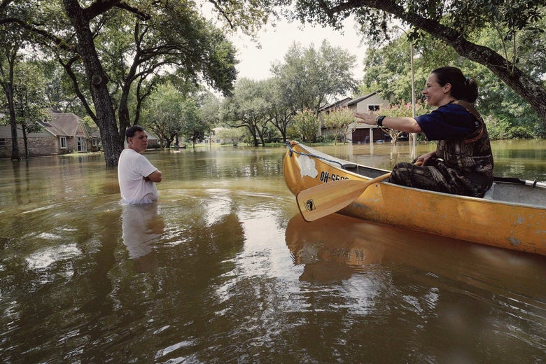
Melissa Ramirez tells Edward Ramirez the status of their flooded home on Sept. 1, 2017, after she returned to it by canoe for the first time since Harvey floodwaters arrived in Houston. Photo by Rick Wilking/Reuters.
Among the Harvey survivors I met were Patti and R.J. Simon; last August was the fifth time their ranch house on Brays Bayou had flooded. They waded to a neighbor’s elevated home. Then they finally moved. At 75, Patti told me she was done with the routine that had accompanied the years in their house since Tropical Storm Allison in 2001. Done putting the couch up on the kitchen counter each time they saw a bad forecast—and too old for it besides. So they left the neighborhood they’d known for decades, where Patti could walk to her job teaching French at the high school, and friends from church could come by and help move the boxes in and out every time the water came in the door. They lost the door frame where they measured the kids. This wasn’t their children’s main concern. “They would have committed us to asylum had we stayed,” she said. Harvey was their third flood in three years.
The Simons aren’t alone: Homes that once flooded rarely, if ever, are suddenly flooding more. The flood plains are on the march, creeping inland from surging bayous. All three of the conduits below Pine Crest—Brickhouse to White Oak to Buffalo, a double-play combination that drains this stretch of northwest Houston—are among the 12 fastest-rising urban waterways in the state of Texas. Since records began more than 50 years ago, Buffalo Bayou’s peak flows are up 250 percent. Brickhouse Gully’s peak is up nearly 400 percent. And White Oak Bayou, over a slightly longer time frame, is up nearly 600 percent. That doesn’t include Harvey, said watershed scientist and consultant Matthew Berg, who published the data. “Pretty much all the time, development is a piece of it,” he asserted. “It’s just a question of how much.” Two in three Houstonians believe lax regulations have made the city’s flooding problems worse.
Dean Bixler is one of them. The house where he and his wife live was built in 1960. It has now flooded three times, all in the past decade. What changed? He pointed to a giant, raised shopping center up the hill. It’s hard to prove these things, but Bixler felt it was obvious: The project had displaced scores of acre-feet (an acre-foot is an acre of water, 1 foot deep), some of which had wound up in his living room. Three times in 10 years. He lost two cars, and, like many people in Houston, he has learned to park up the block, on higher ground. (A joke I heard, which might not be a joke, was that the highest points in Houston are the soaring ramps of highway interchanges.)
Bixler saw in the Pine Crest development a supercharged version of his domestic battle. It wasn’t even in his watershed. But with 900 homes on a little more than 100 acres, Pine Crest was to be among the largest infill projects in the city of Houston, an irresistible morsel for builders and a red flag for wary residents. A Meritage executive said in spring 2017 to the Houston Business Journal, “What we saw was the biggest opportunity available in the city in terms of one tract of land.”
Members of Residents Against Flooding, including Bixler, allege that the map revisions distort how and where the water flows. The revisions were prepared by local hydrological engineers working for the site’s previous owners, MetroNational, and certified by the Harris County Flood Control District on behalf of FEMA. The 2007 map shows the golf course could be under roughly 200 acre-feet of water during a 100-year storm; as the developers carve a channel through the property, removing the banks from the 100-year flood plain, some of that water appears to go missing.

Photo illustration by Lisa Larson-Walker. Flood insurance rate maps via FEMA.
The course has been closed for only a couple of years, but in the tropical climate it has rapidly reverted to nature, with black-eyed Susans and dense scrub filling the fairways between stands of pine. It won’t be wild for long. At the low end is the wide grass halfpipe that will one day funnel runoff from 900 driveways into Brickhouse Gully, part of what Meritage says will be a state-of-the-art drainage-and-detention system that will actually improve conditions downstream relative to the old golf course. On sunny days, it will double as a lovely water feature along which residents can walk their dogs and ride bicycles. To pay for it and other improvements, Meritage got the city to approve a “special utility district,” a geographic tax assessment that will allow a $280 million infrastructure bond issue to be paid off through buyers’ future property tax bills. (It’s a way to pass costs onto buyers.) At the high end, the trees have been felled, and grassless fill rises from the street to escape the 500-year flood mark. Two-story homes, modest and with little flair, are open for tours.
The Harris County Flood Control District, for its part, has looked into all of this at the behest of Residents Against Flooding and stands by its certification of the work by the developers’ engineers. According to Todd Ward, a risk specialist and hydrologist at the Flood Control District, the revisions are just more accurate than the maps from 2007. (After complaints, the agency did its own analysis to verify this.) “When you look at it in more detail, you find there’s a lot more high ground than you might think. The actual volume stored on the site is quite a bit less than [what the 2007 map implies].” The new channel would be deep enough to bring the adjoining land safely out of the 100-year flood plain. The agency also promises that the Meritage development plan will have “no adverse impact” on water levels downstream, meaning that any flooding should be the same or less than if the development weren’t there.
In normal times, the complaints of neighborhood cranks might not be worth much against the word of the county’s hydrological authorities. But confidence in local water guardians is not high. Thousands of plaintiffs whose houses flooded during Harvey have filed suit against the Army Corps of Engineers, which runs the city’s two giant dams, for flooding their homes without warning by releasing water from the reservoirs as they neared capacity.
Meanwhile, the Harris County Flood Control District insists that the past three decades of new development have not caused more flooding—a view that is not widely shared. “People have always said the guy upstream of me is making me flood,” Zeve, of the Flood Control District, told me. “That has been a common theme throughout Houston history and always will be. No one is going to deny that development increases the volume of water, but detention regulates the peak flow.” Not just in theory: Zeve said the agency’s watchful eye has successfully mitigated the effects of new development since the early 1990s. To prove it, the agency has commissioned a peer-reviewed investigation of its own detention requirements (otherwise, he notes with some self-awareness, no one would believe them), and preliminary results suggest their requirements are effective. The city’s recurring flood issues, he argued, can be attributed to huge storms hitting a city largely built before anyone knew what a flood plain was.
Several experts I spoke to found that suggestion—that new development was not having an effect on flooding—ridiculous. As Houston has sprawled westward over the Katy Prairie, 75 percent of its flood-absorbent grasslands have been paved over, turning natural detention basins into roads and houses. In Brays Bayou, on the south side of the city, Rice environmental engineering professor Philip Bedient has found that rainfall is up 26 percent over the past 40 years—but runoff is up 204 percent. From 1996 to 2011, impervious surface in Harris County increased by a quarter, and from 1992 to 2010, the area lost almost a third of its wetlands—nearly 16,000 acres. It’s a correlation that’s been noted again and again. “There’s no question that the amount of impervious surface and the destruction of natural ecosystem surfaces has impacted the amount of runoff and flooding that we have seen,” said Shannon Van Zandt, the head of the landscape architecture and urban planning department at Texas A&M. “There’s no question about that. I don’t think it’s plausible to suggest that the detention is taking care of the issue.”
Critics say the system is built to approve more housing, not deliver objective science. Engineers who sign off on developments, assuring the public they will not contribute to flooding, bid for work from developers, who hire engineers who can make things pencil out. Those houses inside the dam basins whose owners are suing the Army Corps? Certification work for some of those projects was done by an engineering firm run by Houston’s current flood czar, Steve Costello. His firm was so deep in the trade that, when later elected councilman, he had to recuse himself “from more than 60 matters involving his firm, including city flood-control contracts and reviews of municipal utility district deals spread across the region,” according to an investigation in the Houston Chronicle.
Jim Blackburn, an environmental lawyer and professor in the Rice Department of Civil and Environmental Engineering, thinks the county must find a way to end this cozy relationship between engineers and their dual masters, developers and (according to state licensing) the public. One step would be to prohibit the types of flood plain map revisions that the developers had undertaken at Pine Crest. And then some. “As far as I’m concerned, Pine Crest proves the larger point, that we don’t have proper respect for the flood plain. We’re going to have to turn land over to water. Water will demand space in this city whether we like it or not.”
Part Three: Progress
Judge Ed Emmett, the chief executive of Harris County and most powerful politician in the region, agrees: “We’re not going to build our way out of this problem.” The saga over the development of Pine Crest is a Houston city issue, Emmett emphasized, but he said candidly: “It has been a mess.”
In the year since Harvey, the Republican has emerged as a born-again advocate for better flood control. He said Harris County has the strictest building codes and flood plain regulations in the country. It was his decision to schedule the bond issue for the one-year anniversary of Harvey. “When was the last time you saw 85 percent for anything?” he asked the crowd at a supporters’ gathering Saturday night. He’s criticized the way development was conducted for decades (some of it on his watch). Though a champion of the Grand Parkway, the outermost western beltway under construction, Emmett talked conservation at a forum in February: “We need to completely protect the Katy Prairie,” he said of the great plain in western Harris County. “Just set it aside and not touch it.”
There are signs of awakening in the city, too. First Harris County, and then Houston, mandated that all structures in the 500-year flood plain must be built 2 feet above the base flood elevation. The “zero net fill” rule forces all 500-year flood plain builders to dig an equivalent hole for every hill they construct. That’s among the strictest city building codes in the nation, in a place so famous for freewheeling construction that the British architecture critic Reyner Banham compared it to “a real-life Monopoly game.” It’s a recognition that, on this coastal plain, deep into the Anthropocene era, the FEMA maps no longer accurately describe what happens on the ground. (When FEMA updates its maps, the city will revisit those elevation rules.) During Harvey, Houston buildings in the 500-year flood plain were damaged at a slightly higher rate than those in the 100-year flood plain. Now the city has essentially quashed the distinction.
“Of all the flood disasters I’ve lived through, this one seems to be creating more change than in the past,” said Sam Brody, a planner who served on the National Academy of Sciences committee on urban flooding in the United States. Two feet at the 500-year level was not even on the table in 2017. “I was saying 2 feet freeboard at the 100-year level a year ago and people were saying, ‘You crazy academic, that’s never going to happen.’ ”
The homebuilders got their concessions, though. Rather than force builders to elevate structures above the flood line on stilts, the city permitted slab foundations on raised, compacted soil so long as the builder could demonstrate water flows didn’t change. This is a good thing, argues Marvin Odum, the former president of Shell Oil who was appointed Houston’s chief recovery officer after Harvey. “You basically have free rein as long as you don’t alter how water moves off of that property,” he said.
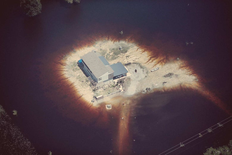
A home is surrounded by floodwater after Harvey’s torrential rains pounded southeast Texas in late August 2017. Photo by Scott Olson/Getty Images.
That’s how Meritage is doing it: houses on mounds, not stilts. While Meritage says all that fill is coming from digging out the property, it’s not obligated to do so under pre-Harvey 500-year requirements. Before the developer received its April go-ahead to create its utility district, the company did extensive outreach with the city council and residents downstream, according to Robert Moore, a vice president of land development at Meritage. “They should feel assured,” he said, “because it’s been checked, double-checked, triple-checked to make sure we aren’t going to have a negative impact on them at all.” Meritage says—and the Flood Control District agrees—that with the carved-out channel and associated ponds, the development will hold more water upstream than the golf course did. The company also suggested that the drainage work it had done before Harvey might have alleviated flooding on Brickhouse Gully, where 2,300 homes were inundated last August.
On approving the utility district, Houston Mayor Sylvester Turner cited the Meritage project as proof that the city’s new code would not scare off the homebuilders who have made the Bayou City a uniquely affordable American metropolis.
The chief risk facing Houston and Harris County is not the vulnerability of new developments, which do tend to be built higher, better, and upstream, but that of the older houses downstream, many built low to the ground and served by undersized storm drains. It may not be the case that your new neighbor upstream is making you flood. But the standards could be higher. Activists say the choice between an abandoned, flood-prone golf course and a subdivision of 900 homes was a false one. Susan Chadwick, the executive director of Save Buffalo Bayou, a group that opposes development in and around the river, argued in June that the city should have used eminent domain on the course to create a detention pond that would relieve Brickhouse Gully.
The engineers at the Flood Control District don’t disagree it would have been a good place for a pool. As we sat in his office going over flood plains, Todd Ward conceded it was a bit of a missed opportunity. We found the course on an enormous satellite map of Houston on the wall. In a giant city, it’s a small square. But there aren’t many undeveloped parcels of that size left. Some of the just-approved $2.5 billion bond will go toward buying out existing repeat-flooding homes downstream of the newly elevated houses at Spring Brook Village. The bond calls for $35 million of channel improvements to Brickhouse Gully to reduce the risk to 1,300 homes.
No matter how much care is put into terraforming, the development will dump more water into the flooded channels than it would had it become a giant detention pond instead. “You can literally measure this thing in gallons going into someone’s living room,” said Albert Pope, a professor of architecture at Rice. “There’s a way to get to fewer gallons.” Pope is one of a growing number of architects, planners, and engineers who argue for an anti-flooding plan that looks not just at what will be built (building codes, detention requirements) but also at what has been built. Those downstream residents are victims. They’re also part of the problem. He is working on a blueprint for a phased retreat of the 100,000 Houston structures that lie within the city’s 100-year flood plain. The bond was a good sign. But he added, “We are close to the end of engineering fixes.”
To John Jacob, a wetland scientist and director of the Texas Coastal Watershed Program, Houston’s long-term strategy must simply be to evacuate the 100-year flood plain. It’s the equivalent of demolishing a midsize American city. “It would be traumatic. It’s not something that should be taken quickly. But it ought to be a goal.” He believes that the city’s bayous, if restored to their full storm-surge size and shorn of encroaching roads and houses, have the capacity to handle another Harvey. That land could be appropriated as a series of linear green spaces akin to D.C.’s Rock Creek Park, with trails, fields, gardens, and paths. It’s an enhanced version of the city’s Bayou Greenways 2020 project, a $220 million investment to assemble a 150-mile network of hiking and biking trails. Houston is not a walkable city, but on the trail that winds along White Oak Bayou, cyclists and joggers share space in the sunken green bend of the floodway. Egrets alight by the water. It’s a glimpse of a Houston where the bayou is something to be loved, not feared.